Thursday, December 31, 2020

Drunk on Paleontology - Cambria Benchbreak Chardonnay


The next Drunk on Geology post is for Cambria Benchbreak Chardonnay from the Cambria Estate Vineyards and Winery in Santa Barbara, CA. 


The name of the winery, Cambria, comes from the geologic time unit, the Cambrian, which lasted from 541 to ~485.4 million years ago. The Cambrian is the first geologic Period within the Era known as the Paleozoic, which also happens to be the first Period within the Phanerozoic Eon (which followed the Precambrian). 
The Geological Society of America's geological time scale. Available here for download in PDF.

Geological time periods are named after people, places, or some aspect to the Earth from which the rocks are found that date to those time periods. The Cambrian and all of the time periods around it are no exception.

The Cambrian was named after Cambria, which is the Roman name for Whales. This is where rocks of this age were first studied by Adam Sedgwick.

The Paleozoic, of which the Cambrian is the first Period within, means "Ancient Life" (paleo = ancient, zoic = life).

And the Phanerozoic, of which the Paleozoic is the first Era within, means "Visible Life" (phaner = visible). 


The Cambrian is a remarkable period within the Earth's history. So much so, that everything before the Cambrian is simply identified as the Precambrian. It was initially thought that the Cambrian represented when life first appeared on Earth, hence it starting off the Visible Life (Phanerozoic) eon. Scientists now know that is not the case, having found fossils and other evidence of life from rocks that are far older than the Cambrian. 

The Geological Time Scale in general was developed by the fossil record. When major animals appeared and disappeared are the basis for the divisions that we now know. Major extinction events mark major boundaries within the time scale such as the Permian Extinction, where 95% of all life on Earth went extinct and marked the end of the Paleozoic, and the Cretaceous extinction, where 80% of all life on Earth went extinct and marked the end of the Mesozoic. 

Treptichnus pedum from the Lower Cambrian. Image courtesy of Buatois, 2017.

The start of the Cambrian, and for that matter the start of the Paleozoic and Phanerozoic (since it is all the same start) is marked by the first appearance of "complex" life. To mark this notable occurrence one particular species needed to be identified. And for this a trace fossil was actually used. Trace fossils are not actual body fossils of animals but marks left behind by the animal, such as footprints, or burrows. And although trace fossils are difficult to ascribe to a particular species, they can generally ascribed to a group of animals based on morphology of the trace left behind. Trace fossils are also given names like body fossils, broken down into ichnogenus and ichnospecies (ichno = trace). For the Cambrian, the trace fossil chosen as the boundary designator is Treptichnus pedum.  

The Cambrian is most well known for the event dubbed the "Cambrian Explosion", which was originally meant to represent the sudden appearance of life on Earth and the quick evolution of new life forms. However, as more fossils are discovered from rock units older than the Cambrian, this moniker has become somewhat incorrect. Although now the Cambrian Explosion has taken on a new meaning. It now represents the explosion of animals with more readily preservable body parts, like shells and skeletons, because without which the fossils are more difficult to discover.

Text from the back of the bottle:
"Our cool coastal vineyard consists of ancient fossilized seashells, shale, limestone and sand. The fog-swept vines have endured since the 1970s. This unique estate sits 400-800 feet above sea level on a bench that overlooks Santa Maria Valley before plunging down to the Sisquoc River. We invite you to experience the results of sustainable farming and artisanal winemaking from our vineyard to your glass. Enjoy."
Upon looking at the location of the winery, the winery itself covers a lot of land within the Santa Maria Valley, which sits upon mostly river alluvium along the valley floor (anything that starts with a "Q" on the map below). However, the wine property also covers some land directly upslope of the valley into the mountains. Here the rocks aren't Cambrian though, they are actually Miocene in age (~17 to 5 million years old). Much, much younger than the Cambrian. 

Geologic Map section where the Cambria Winery is located. Full map with Legend is located at the National Geologic Map Database.

These rocks are part of the Monterey Shale deposit which is a marine, mostly biogenic shale made up of three units, two of which are within the Cambria property boundaries. The lower unit (Tml on the map above) has cream-white weathering, is a thin-bedded fissile semi-siliceous shale, with thin tan dolomitic layers, and a few thin fine-grained sandstone units. The upper layer (Tm on the map above) is similar but doesn't have dolomitic or sandstone layers. 


So, although the winery doesn't sit on Cambrian rocks, it does take its name from one of the the most important time periods in geological and paleontological history, which is a pretty good name to base anything off of.

References

Wednesday, December 23, 2020

Drunk on Astronomy - Shooting Star Pinot Noir


The next Drunk on Geology post is for Shooting Star Pinot Noir from the VML Winery in Healdsburg, CA. 


VML Winery has these absolutely gorgeous labels for some of their wines which denote different cosmological features such as "Sun", "Earth", and here "Shooting Star". For those who don't know, a shooting star is not actually a star at all, but occurs when a bit of rock or other debris enters into the Earth's atmosphere, creating a streak of heated air upon entry. These pieces of rock or other debris can either completely burn up, or only partially burn up, with the remaining portion of the debris coming into contact with the Earth. 


Scientists have several different names for the rocks that travel through our solar system depending on how they interact with the Earth and it's atmosphere. The most general is a meteoroid, which are chunks of rock that are floating in space that are smaller than a kilometer in diameter. A meteor is what would be the scientific term for a "shooting star". These are the flash of light that you see when a meteoroid enters the atmosphere. It is good to note that the meteor specifically refers to the flash of light itself, not the actual object, which is still referred to as a meteoroid. Once that bit of debris reaches the surface of the Earth, it is then identified as a meteorite. 


Two other major objects that travel through the solar system are comets and asteroids. Comets are bodies of ice, rock, and organic compounds that can be up to several miles in diameter that are thought to originate beyond the orbits of the outermost planets. Asteroids are large, rocky bodies (greater than a kilometer in diameter) in orbit around the sun. Asteroids can be composed of rock or metal, like nickel and iron, and most are thought to have formed from the incomplete formation of a rocky planet between Mars and Jupiter, now known as the Asteroid Belt. 


During various times of year there are events known as "meteor showers", this is when there are numerous shooting stars across the sky generally within a short period of time. Although named for the constellation in the sky at the time of the events, these meteor showers are a result of debris shed off from the tails of comets or asteroids as they orbit through the solar system. These are the major meteor showers during the year and when they occur:

Quadrantids        December/January
Lyrids                  April
Perseids               August
Orionids              October
Leonids               November
Geminids            December

The path of Earth crosses various comet's orbits throughout the year creating fields of debris through which the Earth then travels. Image courtesy of NASA

The Quadrantids Meteor Shower is produced by the orbit of asteroid 2003 EH1. Asteroid 2003 EH1 takes 5.52 years to orbit the sun once. It is possible that 2003 EH is a "dead comet" or a new kind of object being discussed by astronomers called a "rock comet."

The Lyrids Meteor Shower is produced by the orbit of C/1861 G1 Thatcher, which was discovered on 5 April 1861 by A. E. Thatcher.

The Perseids Meteor Shower is produced by the orbit of comet 109P/Swift-Tuttle, which takes 133 years to orbit the sun. 

The Orionids Meteor Shower is produced by the orbit of comet 1P/Halley (i.e. Halley's Comet), which takes 76 years to orbit the sun and was named after Edmund Halley who accurately predicted the orbit time and when the comet would next arrive. 

The Leonids Meteor Shower is produced by the orbit of comet 55P/Tempel-Tuttle, which takes 33 years to orbit the sun.

The Geminids Meteor Shower is produced by the orbit of  asteroid 3200 Phaethon, which takes 1.4 years to orbit the sun. Phaethon is also considered to be possibly a "dead comet" or a "rock comet."

References

Friday, December 11, 2020

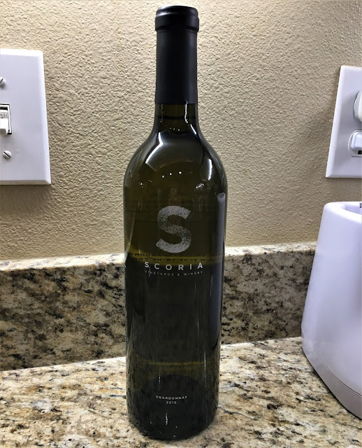
Drunk on Volcanology - Scoria Chardonnay


The next Drunk on Geology post is for the Scoria Chardonnay from the Scoria Vineyards and Winery

The Scoria Vineyards and Winery are located in the same region as the previous Drunk on Geology post, Cinder Wines, the Snake River Plain, and both even have geologically related names. The words "cinder" and "scoria" are often used interchangeably within the geological nomenclature. 

Scoria is a volcanic rock that solidifies as basaltic lava is splattered out of a volcanic vent. Lava is categorized by its chemical composition, which also effects other aspects of it. Basaltic magma is a low silica (quartz) magma, meaning it tends to have a low viscosity (runny), is darker in color (black), it has a high iron and magnesium content (rusts), and it is also generally hotter when it erupts. 

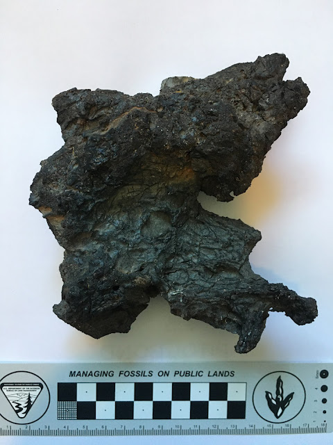
Sample of scoria from Utah's Ice Spings Volcano. 

When you get a specific type of volcanic eruption where the basaltic lava splatters out, the lave then cools in the air with lots of air holes in it. This gives the lava rock a holey, lightweight appearance, like pumice, but black in color (as seen in the picture above). Over time these scoria rocks pile up around the vent eventually creating what is known as a cinder cone volcano. Cinder, again, referring to the scoria rocks.  

Text from the back of the bottle:
"Scoria's chardonnay takes on subtle tropical fruit flavors with expansive finishes of vanilla and French oak.
Our vines root deep into soil laced with dark volcanic scoria rock."
Pathway of the Yellowstone Hotspot across Idaho. Image courtesy of the Digital Geology of Idaho.

Generally, the Scoria Vineyards and Winery are located within the Snake River Plain. This is a region where the Yellowstone Hotspot once passed through. In actuality, the hotspot didn't move but the North American plate passed over the hotspot, creating this string of volcanic eruptions. While the plate passed over the hotspot, the hotspot melted most of this passage and afterwards, this region sank down from the cooling. It is a noticeable plain, devoid of mountains like the surrounding regions. Later, when the western US started to expand, which produced the Basin and Range region, this valley was susceptible to expansion, pulling the plate apart here. That expansion, which thinned the North American crust, combined with the low lying valley, allowed the hotter mantle to heat up this region melting the upper crustal rocks. This produced a score of volcanoes within the valley, including many parts of the western US down through Arizona. 


These volcanic eruptions, many of which were cinder cones, layered the Snake River Plain with scoria deposits. Later lake and river deposits made this valley an extremely fertile region with well drained soil, perfect for vineyards. Hence the reason so many wineries are located within the Snake River Plain. 

Thursday, December 10, 2020

Drunk on Volcanology - Cinder Viognier


The next Drunk on Geology post is for Cinder Viognier from Cinder Wines

Cinder Wines is located in Idaho along the Snake River Plain, and it is a winery that does not shy away from it's geological origins. I was able to visit their tasting room up in Garden City, Idaho and it was fantastic. Unfortunately, the photos I ended up taking of the wines we got from there disappeared. Luckily, we did keep one of the bottles that we got because they were so cool, the Vognier seen above. We got two more wines from there but these (below) are the only pictures I had of those. This is a crop of a much larger picture showing all of the wines we had gotten from that trip. 

The word "cinder" refers to the geological rock known as scoria. Scoria is a basaltic volcanic rock that has a lot of air holes within it and is typically black in color. Think pumice, but black. When volcanoes erupt, they spit up lava. There are many different types of lava depending on the silica content of the lava. The higher the silica content, the thicker the lava. Basaltic lava has a very low silica content and therefore a low viscosity. This low viscosity lava will then be able to flow, like the lava rivers in Hawaii. Sometimes, basaltic volcanoes will erupt by spluttering their lava into the air. As the lava is shot into the air it solidifies and piles up alongside the volcanic vent. Over time these piles of scoria will pile high enough to become a cone, termed a cinder cone. 

Piece of scoria/cinder from the Utah's Ice Springs Volcano. 

Besides just having a low silica content, scoria also has a high iron and magnesium content. Once in contact with the surrounding air and water, this high iron content will sometimes rust, forming a reddish tinge to the rock. If the iron content is high enough, then the rock can turn very red, especially if broken down through erosion. The Cinder Wines tasting room had a lovely panel of scoria (cinder) from the local region (below). This panel mixes the rusted red scoria with the more typical black scoria. 

Scoria display at the Cinder Wines Tasting Room

The patterns depicted within the panel above is also what is artistically recreated on many of the bottles sold at the winery, as seen on the Viognier pictured.

Up close view of the cinder patterns on the bottle.

The geology of the Snake River Plain is complex and Cinder Wines fully embraces it, to the point that the developed a little handout with the geological history of the region. The Snake River Plain initially formed from the passage of the Yellowstone Hotspot over the region. The hotspot essentially melted the crust and produced several eruptions along the way. After the hotspot moved on (or more accurately after this part of the North American plate moved over it, since a hotspot doesn't move), the area of the Snake River Plain cooled off and collapsed down. This created a noticeable, large flat lying valley that lacked the mountains of the neighboring areas. Within this region of the Snake River Plain there also formed a lake within that depression left. This lake, called the ancient Lake Idaho, filled much of the valley shown in the images above. 

Pathway of the Yellowstone Hotspot across Idaho. Image courtesy of the Digital Geology of Idaho

Around this time, there was a subduction zone along the west coast of the United States where the Farallon Plate was subducting (going beneath) North America. This caused North America to be squeezed. However, most of the plate eventually went completely below North America. Because the plate was no longer pushing up against North America, the squeezing was reduced and North America expanded, like a compressed sponge being let go. The expansion of North America produced a region called the Basin and Range, which is an area of alternating valleys and mountains. This expansion also produced a thinning of the crust, which allowed for the hot mantle to melt the crustal rocks producing volcanoes. These volcanoes, which frequently consist of cinder cones, can be found all along the western US from Idaho down through Arizona and California. 


Eventually, ancient Lake Idaho drained out through an area known as Hell's Canyon, leaving behind its nutrient rich soils behind. The Snake and Boise Rivers then began to occupy the abandoned valley. However, that is not all. To the south was the historic Lake Bonneville, the predecessor to the Great Salt Lake. This lake was butting up against the glacial moraines (debris piles) to the south of the Snake River Plain. Eventually these moraines broke (at Red Rock Pass), and cataclysmic flooding of Lake Bonneville proceeded to remove most of the water of the lake through the Snake River Canyon. This flooding deepened the Snake River Canyon, eroded much of the material that was in the canyon, but also deposited a ton of sediment within the valley once the flooding had ceased.  


What remained behind was a region with a complex geological history, rich in nutrients from the lakes and flooding events, as well as a well drained soil from the presence of volcanic rocks. A perfect location for a geological based winery.

Wednesday, December 9, 2020

Drunk on Geomorphology - Rock Slide Organic Red


The next Drunk on Geology post is for Rock Slide Organic Red another Glacier National Park themed wine by Ten Spoon Vineyard. They also released the Going To The Sun Pinot Gris posted about before.

Since the name of the wine isn't Glacier National Park exclusive and I had already done a pretty extensive overview of the park, I will go over what the geological name means. 

A "rock slide" is a type of landslide, otherwise known as a mass movement event. Landslides are the downslope transport of rock, regolith (the layer of unconsolidated rocky material covering bedrock), snow, or ice from a higher elevation to a lower elevation through the force of gravity. Landslides can contain many different types of material and move at many different rates, from so slow it's barely perceptible to a very fast chaotic mess. They can also take place, not only on mountains, such as in Glacier National Park, but also under the water, where they are known as turbidites. 


Rock slides, and landslides in general, fit into geomorphology because they have to do with the evolution of the landscape. Landslides often occur in steep landscapes, where the slope is too steep for the material that is sitting upon it. This type of environment is found high up in mountainous regions, were the majority of the sediment transport is by gravity, but it is not limited to there. 


There are many types of landslides based on environment, materials that are moving, and the speed at which they move. The fastest types of landslide is the rock slide or rock fall mentioned on the bottle. A rock fall or rock slide is when a rock falls along a vertical or sub-vertical cliff. It then proceeds down slope by bouncing and flying along ballistic trajectories or by rolling on talus or debris slopes. The talus is the pile of rocks seen at the base of a cliff or a slope, which is the result of a rock fall or slide. 

A close up, diagrammatic view of a rock slide. Image courtesy of Slide Share, original source unknown.

As seen in the diagram above, rock slides are often linked to the orientation of the bedrock. When the layers of the bedrock are in the same orientation as the slope, this promotes failures of the slope. When a failure occurs, the rocks break off of the surface and falls or slides down to the base of the slope. Failures can be triggered by lots of things including earthquakes, construction machinery shaking the ground, heavy rains making the material on top heavier, or over steepening of the slope by construction, among other causes.

Rock slide along the Going-to-the-Sun Road in Glacier National Park. Image courtesy of Libby, MT News.
Since the Going-to-the-Sun Road needed to be carved out of the valley wall in many places, specifically the steeper portions within the Logan Creek Valley. Here, not only do you already have a steep slope, but it was further steepened by construction of the highway, and then add on to that the heavy snow and rain characteristic of the region makes this road extremely prone to landslides of various types. Here is one instance of a rock slide along the Weeping Wall section of the road back in 2006 after a series of thunderstorms drenched the slope and created a slope that was then too steep for the amount of weight associated with it. 

Text on back of bottle:
"Rockslide shows complex berry and cherry flavors with notes of chocolate and coffee. Made from grapes grown in the Missoula and Yakima Valleys, this wine stands up to Glacier's arbiter of good taste, the Great Bear."

Once a slope surface fails and the rocks start to slide, often additional material will then be knocked loose creating a larger landslide than initially started. Think of an avalanche (another type of mass movement event) where the amount of material at the beginning collects more material on its way down creating a massive movement of material.  

Another great geologically themed wine from Two Spoon Vineyards.